INFRA-COMPASS documentation#
What is COMPASS?#
COMPASS (formally the Infrastructure Continuous Ordinance Mapping for Planning and Siting Systems, or “INFRA-COMPASS”) is an innovative software tool that harnesses the power of Large Language Models (LLMs) to automate the compilation and continued maintenance of an inventory of state and local codes and ordinances pertaining to energy infrastructure.
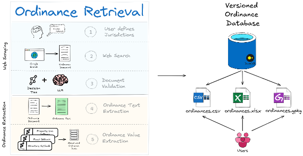
At a high level, COMPASS does two things: it retrieves the right ordinance documents for each jurisdiction you ask about, and then extracts structured data from those documents into a versioned database that downstream users can query as a CSV, Excel workbook, or GeoPackage.
What makes COMPASS different from simply asking ChatGPT for ordinance data is the architecture around the LLM call:
Structured, downstream-ready output — consistent CSV rows with stable column names, units, and feature labels that drop straight into siting and capacity-modeling tools like reV, GIS workflows, or any pipeline that needs setbacks, height limits, and noise thresholds as numbers rather than prose.
Hallucination guardrails — cleaned text is checked against the source and dropped if it drifts too far, so fabricated values never reach the database.
Source-URL traceability — every record carries a URL back to the original ordinance document, so any value can be audited or spot-checked.
Cost control — cheap heuristic filters reject obviously irrelevant text before any LLM call runs, making it tractable to extract data across hundreds of jurisdictions.