Methodology#
The default GradeIT filter uses the five-step method from Wood et al. (2014).
Wood, Eric, E. Burton, A. Duran, and J. Gonder. Appending High-Resolution Elevation Data to GPS Speed Traces for Vehicle Energy Modeling and Simulation. NLR/TP-5400-61109. National Laboratory of the Rockies, Golden, CO (United States), 2014.
Note
This paper is the reference for the method. To cite the software, see Citation on the home page. These are separate references.
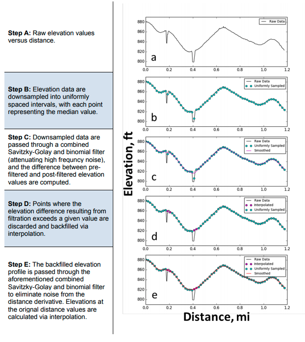
The five steps#
Step A is the raw input. Wood2014Filter does steps B through E.
Step |
What happens |
|---|---|
A |
Raw elevation versus distance, straight from the DEM. |
B |
GradeIT resamples elevation on a uniform distance grid. Each node has the median of raw points in that node. |
C |
GradeIT applies a combined Savitzky-Golay and binomial filter. It calculates the difference before and after filtering. |
D |
GradeIT removes nodes with a filter residual above a threshold. It fills these nodes by interpolation. |
E |
GradeIT filters the filled profile again. It interpolates elevation at the original distances. |
Why step B is important#
GPS traces use time sampling. Therefore, point spacing in distance changes with vehicle speed. In the 250-point Colorado trace, median spacing is 133 ft. Gaps range from 10 ft to 840 ft.
Point-index smoothing gives a filter with a different physical width at each vehicle speed. Resampling to a fixed distance grid gives the filter a fixed width in feet. The paper therefore uses the uniform grid for steps C–E.
Bare-earth bridges and overpasses#
The USGS DEM is a bare-earth product: road infrastructure is not in it. Where a road crosses a river, a valley, or another road, the model describes what is underneath the bridge rather than the road above it.
Step D finds many bare-earth artifacts because they have a large filter residual. It does not need large bridge-specific logic. This includes culverts, creek crossings, and ordinary overpasses.
For spans wider than the smoothing kernel (think a large bridge like the Golden Gate Bridge), use BridgeFilter. It compares each point with a
two-sided rolling-maximum baseline. It can find artifacts that the residual method cannot find.
Set baseline_radius_ft to define the bridge span scale.
This parameter is important since a large valley and a large bridge can look similar to the filter. See real traces in How Filtration Works and Bare-Earth Bridges.