Location and Resource#
The Location and Resource page is where you choose a weather file for the simulation. It provides access to the solar resource library and tools for downloading files from the National Solar Radiation Database (NSRDB).
The solar resource library is a list of CSV files with valid and correctly formatted solar resource data. SAM builds the library from the folders that you identify as containing weather files. When you first install SAM, it comes with a few default weather files stored in the <user>/SAM Downloaded Weather Files folder that are automatically added to the library. As you use SAM for your own projects, you can add and remove folders to manage the library.
There are two ways to add weather files to your solar resource library:
Use the Download button or the Advanced NSRDB Options window to download files from the NSRDB and add them to your library.
Use the Add/remove weather file folders button to add files that are on your computer.
Tip
You may want to model your system using weather data for several different locations around your project site, and if available, from different data sources to understand how sensitive your analysis results are to the weather assumptions, and how much variation there is in the data from the different weather files.
You can compare results for a system using more than one weather file in a single case by using SAM’s parametric simulation option.
For a list of sources of solar resource data other than the NSRDB, see the Weather Data page on the SAM website.
For a helpful discussion of weather data and power system simulation, see the Best Practices Handbook for the Collection and Use of Solar Resource Data for Solar Energy Applications.
See also
Download Weather Files#
The Download Weather File options are for downloading weather files from the National Solar Radiation Database (NSRDB). For information about other sources, see the Weather Data page on the SAM website.
- Type an address or coordinates to download latest NSRDB data
Choose this option to download files from the latest available dataset for one location or for a list of locations. You can download a TMY file, a file for a specific year, or files for all available years.
- Use Advanced NSRDB Options window to access all available data
Choose this option to download 5-minute or 15-minute data for a specific year, or to download files from a specific NSRDB dataset. The Advanced NSRDB Options window displays a list of files from all available datasets for a given location that you can choose from to download. You can also download files directly from the NSRDB using the NSRDB Viewer.
- Download
The Download button is available when you choose Type an address or coordinates to download NSRBD data. Click the button to start the download after typing an address.
- Advanced NSRDB Options
The Advanced NSRDB Options button is available when you choose Use Advanced NSRDB Options window to access all available data. Click the button to open the Advanced NSRDB Options window.
The following inputs are only visible for the Type an address or coordinates to download latest NSRDB data option.
- Address or coordinates
Type a street address, city and state or country name, zip code, or latitude longitude pair. For example:
Golden, Colorado
golden, co
15013 Denver West Parkway, Golden CO 80401
80401
thimpu, bhutan
- File options
Choose the files you want to download from the NSRDB.
Default TMY file downloads a typical meteorological year weather file for the location or locations you specified. TMY data is appropriate when you are using simulation results for a single year to make cash flow calculations over a multi-year period.
Choose year displays a list of available years when you click Download so you can choose a single-year file to download. Single-year files are appropriate when you want to see how the system would perform in a particular year. For example, for a residential or commercial system, if you have measured building load data for a given year, you could use weather data for the same year to see how the system’s power output compares to the load.
Download files for all years (P50/P90) downloads a set of files for all available years. When you click Download, SAM creates a folder in your weather file download folder to store the single-year files based on the location address or latitude-longitude pair you typed. It also downloads the typical meteorological year (TMY) file for the location and stores it in your weather file download folder. SAM appends an underscore with the year to the single-year file names so that the P50 P90 simulations work correctly. See P50/P90 Simulations for details. If you choose to download files for all years with Multiple locations, SAM downloads a set of files for each location, and puts the files for each location in a separate folder.
- One location, Multiple locations
Choose One location to download a weather file for a single location. Choose Multiple locations to download weather files for more than one location.
- List of locations
The list of locations for the Multiple locations option. The button is disabled for the One location option. Click Edit data to open the Edit Data window where you can enter the list of locations. When the window opens, click Number of Values to enter the number of locations in the list, and then type or import a list of addresses and/or coordinates.
- 60-minute, 30-minute
Choose 60-minute to download weather files with hourly time steps or 8,760 data records. Choose 30-minute to download files with 30-minute time steps or 17,520 data records. This option is disabled for the Default TMY file option because TMY files contain hourly data. (To download 5- or 15-minute data, click Use Advanced Options window to access all available data).
- Show Download Log
Click this button to open the <user>/SAM Downloaded Weather Files/sam_nsrdb_download_log.txt file. This file is a running log of your NSRDB downloads and provides information that can be helpful for troubleshooting weather file downloads.
Note
Downloading multiple weather files from the NSRDB can take a long time. If you download files for multiple locations or years, be prepared to wait for the files to download. The download log file reports the time it takes for each file to download. Download times depend on your internet connection and computer. For a new computer with a fast connection, downloading and processing a single file takes about 10 seconds.
The NSRDB API on the NLR Developer Network that SAM uses for weather file downloads requires an email address to download weather file. When you download a weather file from SAM, SAM submits the email address that you used to register SAM.
When you download a file using the Type an address or coordinates to download latest NSRDB data option, SAM uses the NSRDB Data Query API on the NLR Developer Network to identify available NSRDB datasets for a the requested location, and then downloads a file from one of the following datasets depending on the location. For TMY files:
GOES TMY PSM v4.0.0
Himarawi TMY PSM v3
NSRDB Polar Typical Meteorological Year v4.0.0
Meteosat Prime Meridian TMY PSM v4
And, for single-year files:
GOES Aggregated PSM v4.0
Himawari 2016-2020 PSM v3
METEOSAT IODC Region PSM v3
NSRDB Polar v4.0.0
GOES Full Disc PSM v4 (only if files are not available for the location in GOES Aggregated PSM v4).
SAM uses the Mapquest geocoding service through a private NLR Developer Network API to identify the geographic coordinates (latitude and longitude) of a location when you type a street address or city and state name to identify the location.
Choose Weather File#
You can choose a weather file from the solar resource library, or you can disable the library and choose a file directly from a folder on your computer.
- Solar Resource Library
SAM’s solar resource library displays information from weather files in your solar resource data folders. As you use SAM, use Add/remove weather file folders to build a library of files for locations you frequently use as described in Folders and Libraries.
To choose a file from the solar resource library, click the location name in the list. You can type a few letters of the file name in the Search box to filter the list.
The solar resource library is disabled when you check Choose weather file.
Note
SAM comes with a few weather files that it loads when you create a new .sam file. These files are always in your library and are required for SAM to work properly.
- Weather file from library
The full path and file name for the currently selected file in the library.
- Add/remove weather file folders
Click the button to open the Solar Resource Data Folder Settings window where you choose folders on your computer that SAM scans to build the solar resource library. SAM adds any files it can identify as valid weather files in each folder you specify to the library.
Before adding a file to the library, SAM checks the data in the file displays a message if it finds any problems with the data in the file.
SAM only adds valid weather files to the library. If you add a folder that contains CSV files that are not in the SAM CSV format, it will not add those files to the library.
The list of solar resource folders are the folders that SAM scans for weather files to build the solar resource library.
- Refresh library
Refresh the library after adding files to the weather file folder. In most cases, SAM should automatically refresh the library as needed, but you do not see files you just added to the library, click the button to refresh it.
- Choose a weather file
Check this box to disable the solar resource library and enable the Browse button.
- Browse
When the library is disabled, click Browse to choose a weather file directly from your computer. SAM checks the file and displays a message if it finds problems with the data in the file.
Weather Data Information#
The weather data information variables display information about data in the current weather file.
- Weather File
The path and name of the weather file SAM will use for simulation.
- View data
Display weather file data in the time series data viewer.
Note
You can also see the data after running a simulation on the Results page data tables and time series graphs.
Header data is information in the weather file that describes the location and type of data in the file. SAM uses the following information from the header to calculate the sun position during simulations:
Latitude
Longitude
Time zone
Elevation
Time step is the temporal resolution of the weather file in minutes.
Location and Data Source are optional items that provide information about the source of the data that SAM does not use.
When you add a weather file to the solar resource library, SAM reads weather data from the file and calculates annual values to display for your reference. It does not use these annual values during simulations.
- Global horizontal, Direct normal (beam), Diffuse horizontal
The sum of solar irradiance data (W/m 2 ) in the weather file converted to kW and divided by 365 days/year.
- Average temperature
The sum of temperature data (°C) in the weather file divided by the number of records in the file (8760 for hourly data).
- Average wind speed
The sum of wind speed data (m/s) in the weather file divided by the number of records in the file (8760 for hourly data).
- Maximum snow depth
If the weather file contains snow depth data, the maximum value of snow depth data (cm) in the weather file. NaN indicates the file does not contain snow depth data. Snow depth data is required for to model snow losses for the Detailed Photovoltaic and PVWatts models.
Note
If your weather file does not contain snow depth data, and you are using the Detailed Photovoltaic model, you can download data from the Soiling Shading Snow page.
- Annual albedo
If the weather file contains albedo (ground reflectance) data, the average value of albedo values in the weather file. NaN indicates the file does not contain albedo data.
Albedo - Sky Diffuse Model - Irradiance Data (Advanced)#
The albedo, sky diffuse model, and irradiance data inputs are advanced inputs for the detailed photovoltaic model that you can ignore unless you have a reason to change them. These inputs are not available for the PVWatts model, except for some albedo options, which are under Advanced Inputs on the System Design page.
Note
Use the default DNI and DHI and Perez options unless you have a reason to change them.
DNI: Direct normal irradiance, sometimes called beam normal irradiance is the amount solar radiation per unit area that reaches a surface that is normal to the rays of solar radiation from the sun.
DHI: Diffuse horizontal irradiance is the solar radiation per unit area that reaches a horizontal surface from the sky dome, but not directly from the sun. DHI does not include solar energy reflected from the ground. SAM accounts for that separately using the albedo input described above.
GHI: Global horizontal irradiance is the total solar radiation per unit area that reaches a horizontal surface
POA: Plane of array, POA irradiance is equivalent to incident irradiance, and is the total solar radiation per unit area that reaches the surface of the photovoltaic array.
Albedo#
SAM uses the albedo (also called ground reflectance) to make a small adjustment to the amount of solar irradiance incident on the array to represent diffuse irradiance reflected onto the array from the ground. SAM also uses albedo to calculate irradiance incident on the rear side of bifacial modules.
Albedo values must be greater than zero and less than one, where zero represents completely non-reflective ground and 1 represents completely reflective ground.
For most analyses, you can use the default albedo value of 0.2, which is reasonable for grassy ground. A value of 0.6 would be reasonable for snow-covered ground.
After running a simulation, you can see the time series albedo data that SAM uses for simulations on the Results page, and the spatial data on the Spatial tab of the results page.
“Uniform” albedo data represents the albedo that is the same for the entire ground under the array. “Spatial” albedo data represents albedo that is different under and between rows in the array.
- Use monthly uniform albedo values
Choose this option to specify albedo values by month.
Click Edit Values to edit monthly albedo values for each month.
- Use monthly spatial albedo values
Choose this option when you have spatial albedo data by month. The option is available for fixed, one-axis, and seasonal-axis tracking options on the System Design page.
Each column in the spatial albedo matrix represents a rectangular strip of ground under one row of the array and the space between one row and its adjacent row. The leftmost column represents the row closest to the equator. Each row represents a month. The diagram changes with the tracking option on the System Design page and indicates how the matrix represents the ground:
For fixed arrays or arrays with seasonal tilt adjustments, the rectangle is defined by the bottom edges of modules in adjacent rows.
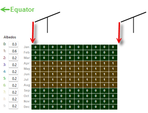
For arrays with one-axis tracking, the rectangle is defined by the tracker posts in adjacent rows.
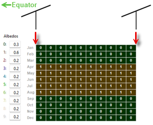
You can specify up to 10 rectangular strips: Use your mouse to select cells in the matrix to represent the strip, and type a number between 0 and 9 for each strip. Then for each strip type an albedo value under Albedos.
To see the resulting albedo, ground irradiance, and rear side irradiance, click the Spatial tab on the Results page after running a simulation.
- Use uniform albedo in weather file if it specified
Check this option if you want SAM to use hourly or subhourly albedo data from the weather file instead of the monthly albedo values. You should also specify monthly albedo values because SAM uses those values for any time steps that have invalid albedo values: For each time step in the simulation, SAM checks the value in the albedo column of the weather file to see if it is between zero and one. If it is within that range, SAM uses that value for the albedo in that hour. If the value in the weather file is outside of that range for a given time step, then SAM uses the appropriate monthly albedo input value for that hour.
If you want to add albedo data to a weather file, you can edit the file using a text editor or spreadsheet software. See the SAM CSV format description for details.
Diffuse Sky Model#
SAM’s detailed photovoltaic model uses DNI and DHI data with sun and subarray angles to calculate the irradiance incident on each subarray. Calculating the incident direct component from the DNI is straightforward, but there are several methods for estimating the incident diffuse component from DHI. The incident diffuse component includes both ground-reflected diffuse irradiance, and sky diffuse irradiance from the sky dome outside of the sun’s circle. SAM allows you to choose the method it uses to convert DHI data to incident sky diffuse irradiance.
The isotropic model tends to under-predict the global radiation on a tilted surface, and is included as an option for analysis comparing SAM results with those from other models using this approach. The HDKR and Perez methods provide comparable estimates of the incident diffuse irradiance.
For more details about these methods, see the photovoltaic reference manual, which is available for download from the SAM website.
- Isotropic
The isotropic method assumes that diffuse radiation is uniformly distributed across the sky, called isotropic diffuse radiation.
- HDKR
The Hay-Davies-Kluchr-Reindl combination method accounts for the increased intensity of diffuse radiation in the area around the sun, called circumsolar diffuse radiation, in addition to isotropic diffuse radiation.
- Perez
The Perez method is the default value and is best for most analysis. It accounts for horizon brightening, circumsolar and isotropic diffuse radiation using a more complex computational method than the Reindl and Hay and Davies methods.
Weather File Irradiance Data#
A weather file in SAM CSV format for the photovoltaic performance models must contain at least two columns for the solar irradiance components or a single column for plane-of-array (POA) irradiance. The weather file may contain columns for all three irradiance components in addition to POA data. SAM determines which columns to use for the simulation based on the Weather File Irradiance Data options you choose.
Unless you choose one of the POA options, SAM’s detailed photovoltaic model always requires the DNI and DHI components to calculate the irradiance incident on each subarray. When you choose the DNI and GHI or GHI and DHI options, SAM calculates values for the missing irradiance component from the two components that you specify, even if the weather file contains data for the missing component. When you choose a POA option, SAM bypasses the incident irradiance calculations.
- DNI and DHI
SAM reads the direct normal irradiance (beam) and diffuse horizontal irradiance data from the weather file. For this option, SAM calculates incident irradiance using the DNI and DHI data from the weather file without any additional calculations. This is the default option, and is best for most analyses because it minimizes the number of irradiance calculations.
- DNI and GHI
SAM reads the direct normal irradiance (beam) and global horizontal irradiance (total) data from the weather file, and calculates the diffuse horizontal irradiance values for simulations. SAM calculates the incident irradiance using the DNI data from the weather file and the calculated DHI data.
- GHI and DHI
SAM reads the global horizontal irradiance (total) and diffuse horizontal irradiance data from the weather file, and calculates direct normal irradiance values for simulations. SAM calculates the incident irradiance using DHI data from the weather file and the calculated DNI data.
- POA from reference cell
Use this option if your weather file contains irradiance data measured in the plane of the array by a reference photovoltaic cell that has the same optical characteristics as the cells in the array. SAM assumes that the POA data accounts for angle-of-incidence (AOI) effects and removes the calculation of AOI-related reduction in incident DNI from the performance model.
- POA from pyranometer
Use this option if your weather file contains irradiance data measured in the plane of the array by a pyranometer. SAM uses a POA decomposition model to calculate the DNI and DHI components of the POA irradiance for angle-of-incidence effect calculations.
Note
For a technical description of the POA option, see Freeman (2016) Using Measured Plane-of-Array Data Directly in Photovoltaic Modeling: Methodology and Validation, available from https://sam.nlr.gov/photovoltaic/pv-publications.
When you choose a POA option, SAM uses an irradiance decomposition model to calculate DNI and DHI values, which it reports in the results for your reference. It only uses the calculated DNI and DHI values under the following conditions:
With the POA from pyranometer option to calculate a reduction in DNI due to angle-of-incidence effects.
When you enable external shading, SAM applies the beam and diffuse irradiance shading factors to the calculated DNI and DHI values, and then calculates the irradiance incident on the subarray to account for shading.
When you use the CEC module model with the heat transfer method for temperature correction.
When you use POA data, be careful to check that your array orientation, shading, soiling, and snow model inputs are consistent with your POA data. If your system has more than one subarray, SAM uses the POA data for each subarray. This requires that all subarrays have the same orientation and tracking, but SAM does not enforce this requirement. SAM also allows you to enable shading, soiling, and the snow model with POA data. If the irradiance data already accounts for these effects, you should disable those inputs.
Irradiance Data in Results#
Note
If your weather file contains data for all three irradiance components, the value of the calculated third component that SAM uses for the simulation may differ from the value in the weather file.
You can see the calculated data on the Results page after running a simulation, for example, on the Data tables tab and Time series tab:
- Irradiance GHI/DNI/DHI/POA from weather file (W/m2)
The data in the weather file. If the column does not exist in the weather file, SAM reports the values in the results as NaN (not a number).
- Irradiance GHI/DNI/DHI calculated (W/m2)
The values of the third irradiance component that SAM calculates from the other two in the weather file. For example, if you choose the DNI and GHI option, you should see Irradiance DHI calculated in the results. SAM uses the following equations for the calculated values, where z is the sun zenith angle:
GHI = DHI + DNI × cos(z)
DHI = GHI - DNI × cos(z)
DNI = ( GHI - DHI ) ÷ cos(z)
For the POA options, SAM calculates the DHI and DNI values from the POA data in the weather file using the method described in Marion, B. (2015) “A model for deriving the direct normal and diffuse horizontal irradiance from the global tilted irradiance.” Solar Energy, vol. 122, pp. 1037-1046.
- Subarray n POA total irradiance after shading and soiling (W/m2)
The total irradiance incident on each subarray n.